The universal locator
Understanding the GPS
The GPS system is based on a network of 24 satellites which orbit around the world at an altitude of 20 178 km (base orbit.) These satellites emit information on their position and the exact hour (atomic clock)… This information is received by the GPS receiver and permits it to calculateposition. On a GPS receiver everything is automatic, it captures signals from the satellites it surveys and works out its position. In order to do this from a position without altitude, it must receive signals from at least 3 satellites. The more satellites viewed, the more accurate the position. Fixed or portable, regardless of brand or price, all GPS receivers work with the same satellites and display the same position, within a precision of the order of tens of metres for a moving vessel.
For improving the accuracy
To improve this precision, ground stations permanently calculate positions and send them toward two geostationary satellites: WAAS (Wide Area Augmentation System,) for the Pacific and EGNOS (European Geostationary Navigation Overall System,) for Africa and Europe. These satellites send positional information toward GPS capable of interpreting them. With these systems, we have reached accuracy within the order of 2 to 5 m. These new generation models are all WAAS/EGNOS compatible.
Other information provided by the GPS.
Starting with the geographical position, the GPS provides a wealth of information, including;
-Boat speed over the ground (SOG)
- Boat course over the ground (COG)
- Distance and course toward a fixed point.
-Arrival time (ETA)
- Course chart (XTE.)
Caution, a GPS is not a compass (unless it has an integrated electronic compass,) reliable direction is indicated only if the boat is moving. One may programme a route plan (which indicates crossing points, waypoint.) From this plan the GPS indicates the course to steer, distance to a point, speed, time remaining, route chart, journey record…One may also connect the GPS to the pilot, which then follows the programmed route.
Types of GPS.
Active antenna GPS.
A GPS, “black box.” Functions with a simple antenna. All electronics are contained in the antenna, which must be connected to a 12V supply to make it work. GPS information will be transmitted to another apparatus (card reader, computer…) for interpretation.
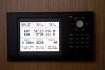
Fixed GPS.
The fixed model is installed at the chart table inside the boat, under a cover, in the wheelhouse or at the control panel on a motor boat. It must be a dedicated marine version. When the GPS is installed to the boat’s interior, it is advisable to select a model with an external antenna. Although very powerful today, integrated antennas may not function, depending on the materials the boat is constructed from. The important points to consider are: the screen quality, the waterproofing and the mounting. Outside, it must be visible in direct sunlight. If the GPS is exposed it must be waterproof. If it is housed, the spray proof or runoff versions may be adequate. In certain cases one may need to disassemble it when leaving the boat (notably, to protect it from theft.) In this case there are easy release models.
Portable GPS
The portable GPS has exactly the same features as its fixed counterpart, but integrated power supply to provide autonomy. No question of an external antenna, the portable comes with antenna built in. One looks for a waterproof model with long lasting power. Certain of them are equipped with rechargeable batteries, others, spare batteries and some with both. Remember, this type of GPS may be used in an emergency, in case the principal GPS breaks down, or even, in case of distress, be taken in the raft with you.
GPS with cartography
Electronic cartography is increasingly available on the GPS. When it displays an electronic map, the GPS transforms itself into a card reader. These units may be portable or fixed. Their quality depends primarily on the screen size. It is obvious that for navigation, especially on a habitable boat, a screen, a few centimeters in size is not ideal, it really needs to be at least four inches across. It is not a question of the quality of mapping, this is the same regardless of screen size (fixed or portable,) it is the reading comfort. However, on a small boat, on a daytrip for example, due to the integrated power supply, a small GPS is practical and often sufficient. Consider also that certain GPS may be used for numerous activities (driving, hiking, skiing etc...)
A GPS, “black box.” Functions with a simple antenna. All electronics are contained in the antenna, which must be connected to a 12V supply to make it work. GPS information will be transmitted to another apparatus (card reader, computer…) for interpretation.
Fixed GPS.
The fixed model is installed at the chart table inside the boat, under a cover, in the wheelhouse or at the control panel on a motor boat. It must be a dedicated marine version. When the GPS is installed to the boat’s interior, it is advisable to select a model with an external antenna. Although very powerful today, integrated antennas may not function, depending on the materials the boat is constructed from. The important points to consider are: the screen quality, the waterproofing and the mounting. Outside, it must be visible in direct sunlight. If the GPS is exposed it must be waterproof. If it is housed, the spray proof or runoff versions may be adequate. In certain cases one may need to disassemble it when leaving the boat (notably, to protect it from theft.) In this case there are easy release models.
Portable GPS
The portable GPS has exactly the same features as its fixed counterpart, but integrated power supply to provide autonomy. No question of an external antenna, the portable comes with antenna built in. One looks for a waterproof model with long lasting power. Certain of them are equipped with rechargeable batteries, others, spare batteries and some with both. Remember, this type of GPS may be used in an emergency, in case the principal GPS breaks down, or even, in case of distress, be taken in the raft with you.
GPS with cartography
Electronic cartography is increasingly available on the GPS. When it displays an electronic map, the GPS transforms itself into a card reader. These units may be portable or fixed. Their quality depends primarily on the screen size. It is obvious that for navigation, especially on a habitable boat, a screen, a few centimeters in size is not ideal, it really needs to be at least four inches across. It is not a question of the quality of mapping, this is the same regardless of screen size (fixed or portable,) it is the reading comfort. However, on a small boat, on a daytrip for example, due to the integrated power supply, a small GPS is practical and often sufficient. Consider also that certain GPS may be used for numerous activities (driving, hiking, skiing etc...)
Tips
A complex choice? Yes and no. Good advice: if you have multiple GPS on board, for example a fixed and a portable, take them from the same brand with compatible cartography and same format cartridge. We are here to direct you.
A complex choice? Yes and no. Good advice: if you have multiple GPS on board, for example a fixed and a portable, take them from the same brand with compatible cartography and same format cartridge. We are here to direct you.
Taking account of the standard NMEA
The GPS signal may be used by several other devices on board. This is the case for the VHF DSC, AIS, the card reader, the central navigation, the computer…We must make sure that these devices interface together. Two standards exist today. The oldest is the NMEA 183. It is not very accurate and each maker interprets it a little differently. For almost 20 years of use it has been known for its strengths and weaknesses. Ask at your AD store, they will inform you of any problems of compatibility between devices. In recent years the new standard NMEA 200 has emerged. It is based on CAN bus technology. Plugs and fittings are standard and all devices (even different brands,) may communicate with one another. It is toward this that one must direct oneself because future marine electronics will work through it. Today there are adaptors to facilitate communication from NMEA 183 devices to NMEA 2000.
Professional advice
“I choose a fixed GPS for use on board and equip myself with a waterproof GPS for my survivalbag. The portable works also, as an emergency GPS in case of any problems with the fixed.”