
Description
The legendary all-terrain GPS 276C is back
Developed from the versatile GPSMAP 276C and just as customisable
Includes more sensors: GPS + GLONASS, altimeter and 3D compass
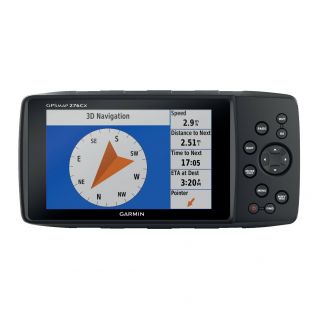
Large 5-inch WVGA anti-glare display
Optional advanced navigation features: Drive mode, TTS voice guidance, winding roads, etc.
Connection via Bluetooth®, ANT+® and Wi-Fi®, so you stay in touch
Pre-loaded 1/100,000 TOPO Europe mapping with one year subscription to BirdsEye satellite imagery
More mapping options, including support for BlueChart® g3 and TOPO maps
If you want to enjoy the best navigation experience possible with Garmin, then the GPSMAP 276Cx is for you. This navigation GPS provides accurate directions wherever you are, even off-road or on the water. The new 276Cx includes a whole range of top-of-the-range navigation functions, without the limitations imposed by the original 276 model. With its large 5-inch screen, sensors (GPS + GLONASS, barometric altimeter and 3-axis electronic compass), comprehensive marine and outdoor functions and maps, the new GPSMAP 276Cx is a worthy successor to this legendary product range.
The true 276C experience
The new GPSMAP 276Cx has been developed on the basis of the legendary GPSMAP 276C, known as the most versatile outdoor navigation device ever designed by Garmin. To maintain the experience of the 276 range, Garmin has kept most of the interface elements, including the keyboard. Fans of the 276 series will appreciate the many ways they can customise their navigator and will be impressed by the new features added to the original 276 model.
High-tech sensors
The technology built into the GPSMAP 276Cx has undergone a complete upgrade. The device receives both GPS and GLONASS signals, making it more accurate in extreme environments. To optimise reception of satellite signals in vehicles, you can add an external antenna (not included) to the device's built-in MCX connector. To improve your knowledge of the environment around you, the device includes a barometric altimeter providing altitude data and a 3-axis electronic compass showing precise elevation changes in all conditions.
User interface optimised for outdoor activities
We know how important it is for directions and maps to be displayed legibly while you're out and about. That's why the GPSMAP 276Cx has been equipped with a 5-inch anti-glare display in rich colours. It offers perfect legibility wherever you are in relation to the screen. Even in a cockpit, its large screen and button interface mean you can use it safely in rough conditions, such as on a boat or in an off-road vehicle.
Rugged and tough
Engineered to Garmin's highest standards, this device works in almost any condition. It is extremely robust and meets the IPX71 standard for water resistance. Having worked on the Montana® for 4 years, we are able to supply solid mounting brackets that fit almost any existing vehicle or boat. To give you even more freedom, the GPSMAP 276Cx comes with several power systems: you can plug it directly into the power supply of your vehicle or boat, use the lithium-ion battery pack (17-hour battery life) or insert 3 AA batteries (9-hour battery life).
More maps and more memory
The maps available with the GPSMAP 276Cx can take you almost anywhere. The device includes 8 GB of internal memory, a world map base, 1/100,000th TOPO Europe mapping and a one-year subscription to BirdsEye satellite images. It also supports a number of optional maps, including BlueChart® g3 HD marine maps, Garmin TOPO and TOPO PRO maps, City Navigator® NT maps, Garmin custom maps and BirdsEye Select raster maps. Even more navigation options
In addition to maps, the GPSMAP 276Cx offers additional navigation functions, such as the famous Drive mode for road navigation or the 'Winding Roads' function, which allows motorcyclists to choose the smaller, more pleasant roads. Thanks to the TOPO PRO maps, the device can choose the best route, depending on the type of terrain suited to the vehicle or activity chosen. For those who prefer routes and circuits, the new 276Cx also provides advanced circuit navigation options.
Connectivity features
The new GPSMAP 276Cx also comes with a number of connectivity features. You can connect your 276Cx to a Bluetooth headset to receive TTS instructions. If you connect it to a smartphone, you can enjoy not only Dynamic Weather3, which provides you with weather forecasts and an animated radar view on your map, but also Smart Notifications, such as emails, text messages or social network messages, or LiveTrack, which lets you share your exact location with friends and family. The GPSMAP 276Cx can also connect via the ANT+ wireless network to external sensors, such as tempe<, which measures external temperature, or via Wi-Fi to receive updates and synchronise with Garmin Connect<.
Support for BlueChart® g3 marine maps. dim: 191.5 x 94.5 x 44 mm. 800 x 480 pixel WVGA display. Rechargeable lithium-ion battery (included). Operating time: 16 hours. Waterproof to IPX7. Compatible with Hi-Speed USB and NMEA 0183. accepts microSD cards.
in the box: GPSMAP 276Cx-One-year subscription to BirdsEye satellite imagery1-AMPS-powered mounting bracket with boat clamp-Rechargeable lithium-ion battery-USB cable-Mains charger-Documentation.
1See Water resistance
2Must be paired with a compatible phone
3Dynamic weather function is available in the following countries: United Kingdom, Ireland, Portugal, Spain, France, Germany, Belgium, Netherlands, Luxembourg, Switzerland, Denmark, Norway, Sweden, Finland, Austria, Slovenia and part of northern Italy.
Support for BlueChart® g3 marine maps. dim: 191.5 x 94.5 x 44 mm. WVGA display 800 x 480 pixels. Rechargeable lithium-ion battery (included). Operating time: 16 hours. Waterproof to IPX7. Compatible with Hi-Speed USB and NMEA 0183. accepts microSD cards.
In the box: GPSMAP 276Cx-One-year subscription to BirdsEye1 satellite images-AMPS-powered mounting bracket with boat clamp-Rechargeable lithium-ion battery-USB cable-Mains charger-Documentation.
Wi-Fi® is a registered trademark of the Wi-Fi Alliance. The Bluetooth® word mark and logos are owned by the Bluetooth SIG, Inc. and any use of such marks by Garmin is under licence.
Developed from the versatile GPSMAP 276C and just as customisable
Includes more sensors: GPS + GLONASS, altimeter and 3D compass
Large 5-inch WVGA anti-glare display
Optional advanced navigation features: Drive mode, TTS voice guidance, winding roads, etc.
Connection via Bluetooth®, ANT+® and Wi-Fi®, so you stay in touch
Pre-loaded 1/100,000 TOPO Europe mapping with one year subscription to BirdsEye satellite imagery
More mapping options, including support for BlueChart® g3 and TOPO maps
If you want to enjoy the best navigation experience possible with Garmin, then the GPSMAP 276Cx is for you. This navigation GPS provides accurate directions wherever you are, even off-road or on the water. The new 276Cx includes a whole range of top-of-the-range navigation functions, without the limitations imposed by the original 276 model. With its large 5-inch screen, sensors (GPS + GLONASS, barometric altimeter and 3-axis electronic compass), comprehensive marine and outdoor functions and maps, the new GPSMAP 276Cx is a worthy successor to this legendary product range.
The true 276C experience
The new GPSMAP 276Cx has been developed on the basis of the legendary GPSMAP 276C, known as the most versatile outdoor navigation device ever designed by Garmin. To maintain the experience of the 276 range, Garmin has kept most of the interface elements, including the keyboard. Fans of the 276 series will appreciate the many ways they can customise their navigator and will be impressed by the new features added to the original 276 model.
High-tech sensors
The technology built into the GPSMAP 276Cx has undergone a complete upgrade. The device receives both GPS and GLONASS signals, making it more accurate in extreme environments. To optimise reception of satellite signals in vehicles, you can add an external antenna (not included) to the device's built-in MCX connector. To improve your knowledge of the environment around you, the device includes a barometric altimeter providing altitude data and a 3-axis electronic compass showing precise elevation changes in all conditions.
User interface optimised for outdoor activities
We know how important it is for directions and maps to be displayed legibly while you're out and about. That's why the GPSMAP 276Cx has been equipped with a 5-inch anti-glare display in rich colours. It offers perfect legibility wherever you are in relation to the screen. Even in a cockpit, its large screen and button interface mean you can use it safely in rough conditions, such as on a boat or in an off-road vehicle.
Rugged and tough
Engineered to Garmin's highest standards, this device works in almost any condition. It is extremely robust and meets the IPX71 standard for water resistance. Having worked on the Montana® for 4 years, we are able to supply solid mounting brackets that fit almost any existing vehicle or boat. To give you even more freedom, the GPSMAP 276Cx comes with several power systems: you can plug it directly into the power supply of your vehicle or boat, use the lithium-ion battery pack (17-hour battery life) or insert 3 AA batteries (9-hour battery life).
More maps and more memory
The maps available with the GPSMAP 276Cx can take you almost anywhere. The device includes 8 GB of internal memory, a world map base, 1/100,000th TOPO Europe mapping and a one-year subscription to BirdsEye satellite images. It also supports a number of optional maps, including BlueChart® g3 HD marine maps, Garmin TOPO and TOPO PRO maps, City Navigator® NT maps, Garmin custom maps and BirdsEye Select raster maps. Even more navigation options
In addition to maps, the GPSMAP 276Cx offers additional navigation functions, such as the famous Drive mode for road navigation or the 'Winding Roads' function, which allows motorcyclists to choose the smaller, more pleasant roads. Thanks to the TOPO PRO maps, the device can choose the best route, depending on the type of terrain suited to the vehicle or activity chosen. For those who prefer routes and circuits, the new 276Cx also provides advanced circuit navigation options.
Connectivity features
The new GPSMAP 276Cx also comes with a number of connectivity features. You can connect your 276Cx to a Bluetooth headset to receive TTS instructions. If you connect it to a smartphone, you can enjoy not only Dynamic Weather3, which provides you with weather forecasts and an animated radar view on your map, but also Smart Notifications, such as emails, text messages or social network messages, or LiveTrack, which lets you share your exact location with friends and family. The GPSMAP 276Cx can also connect via the ANT+ wireless network to external sensors, such as tempe<, which measures external temperature, or via Wi-Fi to receive updates and synchronise with Garmin Connect<.
Support for BlueChart® g3 marine maps. dim: 191.5 x 94.5 x 44 mm. 800 x 480 pixel WVGA display. Rechargeable lithium-ion battery (included). Operating time: 16 hours. Waterproof to IPX7. Compatible with Hi-Speed USB and NMEA 0183. accepts microSD cards.
in the box: GPSMAP 276Cx-One-year subscription to BirdsEye satellite imagery1-AMPS-powered mounting bracket with boat clamp-Rechargeable lithium-ion battery-USB cable-Mains charger-Documentation.
1See Water resistance
2Must be paired with a compatible phone
3Dynamic weather function is available in the following countries: United Kingdom, Ireland, Portugal, Spain, France, Germany, Belgium, Netherlands, Luxembourg, Switzerland, Denmark, Norway, Sweden, Finland, Austria, Slovenia and part of northern Italy.
Support for BlueChart® g3 marine maps. dim: 191.5 x 94.5 x 44 mm. WVGA display 800 x 480 pixels. Rechargeable lithium-ion battery (included). Operating time: 16 hours. Waterproof to IPX7. Compatible with Hi-Speed USB and NMEA 0183. accepts microSD cards.
In the box: GPSMAP 276Cx-One-year subscription to BirdsEye1 satellite images-AMPS-powered mounting bracket with boat clamp-Rechargeable lithium-ion battery-USB cable-Mains charger-Documentation.
Wi-Fi® is a registered trademark of the Wi-Fi Alliance. The Bluetooth® word mark and logos are owned by the Bluetooth SIG, Inc. and any use of such marks by Garmin is under licence.
Technical characteristics
| Length | 191.5 mm |
|---|---|
| Product Brand | Garmin |